
Try new Earthworks website www.earthworkssoftware.info
Earthworks design ready by next day
Have you ever find that you are spending substaintial of time on the process of designing earthworks?
Imagine that if you have a chance to expidite this?
Do you want to do so? YOU CAN GO HOME EARLY..
Our simplicity makes a difference. Our ZeonEarth-3D earthworks software can help you to ready a project earthworks design by tomorrow. It can be as simple as by mouse clicks to complete the earthworks design.
Main feature of Zeon Earth 6.0 - Furniture (Full edition and SE edition)
One of the importation tasks in construction industry is the earthworks. The earthworks is a must in any land construction. In the earlier time where computer is not available, engineer or contractor need to takeoff quantities by manually. The method of takeoff is simple but tedious. Most of people will go for grid method or cross section method. It mainly depends on type of construction being carried out. For example, in highway project, cross section method will be more suitable for it. Where else, the grid method may suitable for housing development.
Anyway, when business become more competitive. Clients become more demanding. Earthworks is increasingly challenging. Clients need to have result more quickly. Most of the time, firm like Quantity surveyor consultants, contractors or consulting engineers, they will do it manually by working overnight or by the help of compute to do takeoff. Now, with the growth of IT, now you can easily get an earthworks software online. You can goto online website to get some earthworks software. It may also raise issue of which is the best software to be used. To select a software. There are many factors need to consider. Lets take an example Do you want to have a powerful software but not easy to use or less powerful but easy to use? A powerful software but it is not easy to operate. You may go through few days of training. Then you need to back to office to learn and familiar with the commands and usages of software. It may take you to have an initial startup up to few days. What mean that to get an output i.e. cut and fill volume of earthworks. Our software cannot be competed with it. Our ZeonEarth has a special feature that it can run it can be as short as of 5 minutes to perform the computation.
Our ZeonEarth Earthworks software in Malaysia that run on its own CAD platform. It is used to perform quantity takeoff.
The methodology of software is based on triangulation method or digital terrain method to compute cut and fill volume of earthworks in 3D. Besides, it also comes with grid method and cross section method by prismoidal formula or end areas method.By these three earthworks methology, user can has confidence on our result computation.
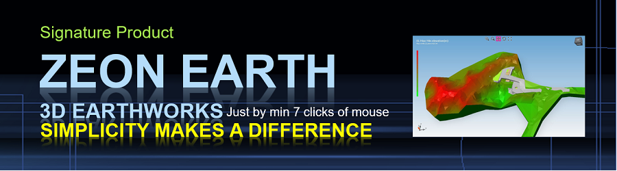
Our Zeon Earth engine, user can has outcome togther with impressive 3D view. In which the 3D output can be used as presentation to customers. Besides, it also can generate contour lines for a given survey data in text entities.
Our earthworks taking off software-ZeonEarth where has a special feature that can capture "funny" land surveyor data such as broken surveyor points in CAD layout.
Now the grid method and cross section method are auto-generated by click of button. User can expedite on quantity takeoff.
This earthworks software is suitable for civil and structural consulting engineers, earthworks contractors and property developers that have their inhouse design office to takeoff earthworks quantities. It includes cut and fill volume, cut and fill layout and fully 3D view.
A lot of people is talking about accuracy of earthworks. Please note that in reality we cannot have exact volume of cut and fill. Such as we cannot cut earth to a 90 degree wall especially on soft ground. Anyway, our earthworks accuracy is solely depends on given points in analysis. The more points provided, the more precise of result generated. Minimum points required are Three(3) points.
One more wonder of our ZeonEarth is the auto profiling without much interruption by human. It will automatically plot necessary profiles by computer.
Earthworks Software Editions:
It comes with two editions which are Basic edition, Full edition and Special edition.
Basic edition with limited on 3D computation with 2D cut and fill layout, 3D model and basic profiling.
Full edition with all features available in Basic with unique and EXTRA features
Unique Features:
- ["Ready design by next day"]
The simplicity can make you ready earthworks design by next day. - ["By mouse clicks"]
Our ZeonEarth can complete earthworks design can be as simple as mouse clicks. - ["Can model any shape"]
Our ZeonEarth can model any given project into 3D model.Find out more here - [Documents]
A software is not a complete software without documents. Now we come with a number of documents which supporting our ZeonEarth like Tips and Tricks. Now we have Essential of Earthworks, our Tips and Tricks and Tutorials will lead you toward a comprehensive earthworks design. - ["Layman" Operator]
Our ZeonEarth can be operated by "layman". For instance, Some CAD software needs to have highly technical sound personal to operate where our software can operate by draftperson. As long as draftperson can understand some basic knowledge of earthworks. For example, what is existing levels and proposed levels. It can cut down cost on manpower. - [Short learning curve]
Short learning curve is one of our key feature. It can cut down problem of software operator being �hijacked� by other company. It can take as short as 1/2hours to get started. As compare to some CAD software needs few days of training. Any person can easily being replaced. - [Time saving in data preparation]
Besides, our software is fully operated in CAD dwg. In conventional way, initial earthworks drawing is coming from land surveyor. Land surveyor captures levels from sites and presented in CAD drawing. Norm, by dwg format. From the dwg drawing, user will enter more data such as final levels or proposed levels. Here, with existing and final levels, quantity takeoff can be performed. Our software is fully CAD compatible. ZeonEarth can read directly from CAD dwg without major touching up the dwg drawing but with certain guidelines need to be followed. In a way, it reduces double works in data preparation. In ZeonEarth does not need re-entry data. Therefore, time saving happened. One time works in CAD drawing can be used in our software. - [Confidence-Three method of takeoff quantities]
One of our unique feature is our ZeonEarth comes with three method of takeoff. 3D method, grid method and cross section method. Most of software come with one methodology of takeoff. Our ZeonEarth can be used to make comparison of takeoff by difference methods. Here, engineering judgement can be performed. It reduces worry on accuracy of result. Subjected to ZeonEarth edition. - [Simplicity in operation of software]
Another goody of our ZeonEarth, user can get it run can be up to as short as 5 minutes operation to get a count. i.e. one earthworks computation. It no need to go through many steps in order to get it run. Thus, user can perform more test on earthworks computation. - [Output in CAD dwg drawing]
Our output mainly produces in CAD. Therefore, it is easily to be handled without need any other software to open it. It can be opened in AutoCAD, BricsCAD, ZWCAD, GStart and other CAD compatible software. - [3D output]
Our Zeon technology can produce a nice 3D earthworks output where it is very useful to present to clients. - [Tested for many projects]
Our Zeon technology has been tested on many projects which show on the correctness and stability. - [Auto profiling for terrain]
Our automation of profiling makes you save time on thinking of location of profile required. It just plot for you to select it.
General Basic Earthworks Features:
- Read text entities by layers with filter system from land surveyor data in dwg format.
- Set earthworks boundaries
- 3D or digital terrain method
- Grid methodology and cross section method(end ares method and prismoidal formula) on earthworks takeoff (Not available for Basic Edition)
- Define platforms
- Generate contour lines
- Generate 3D base surface example existing levels
- Generate 3D compare surface example proposed levels
- Generate combinated 3D of base and compare surfaces
- Compute cut and fill layout by area
- Compute cut and fill volume
- Create high quality profile(cross section) in any direction on layout. (To be exported to xSection. Where it can be edited in xSection-Not available for Basic edition).
- Quantity take off and breakdown calculation in digital terrain
- Video in Youtube
- Online help file
Extra Features(NOT available for basic Edition):
Besides our mainly features, we do have additional or extra features that can help user to do a better earthwork.
- [Furniture]
3D elements besides basic 3D model like house, shop, terrace, factory, guard house, gate, fencing, and many more to enhance your conceptual to your client. Ready ++40 templates for you. - [Auto Slope Generation]
An earthworks software cannot comes without Slope Generation. Here our new Slope generation will come along with Zeon Earth. - [Slope classification]
By given slope criteria, our ZeonEarth can work out slope angle to horizontal by demarking into CAD layout with colors. It can be used to identify location of high risk and low risk slope. - [Auto Balance Cut and Fill]
It will be good if a site can achieve a balance between cut and fill. With this feature, our ZeonEarth can try to work out the best of auto balance between cut and fill volume. Anyway, it may not get a good earthworks design. In order to get a good earthworks design, certain earthworks criteria need to fulfil. - [Preliminary proposed levels]
Our ZeonEarth can proposed initial levels for user to start up the earthworks. It uses the existing terrain to capture corresponding existing levels to points of consideration. It makes user easy to startup without spend a substantial of time on studying the existing levels. - [Flow Map]
Our flow map on existing levels give user a clue on during raining time, how the surface water will run. It provides important information especially on ESCP study. Erosion and sediment control plan. As for example, location of sediment basin. The basin can be easily located by studying the flow map. Even the temporary earth drain can be located by the flow path in flow map. - [3D Pond]
Now it comes with 3D pond with a polyine drawn in CAD with a base level of pond - [3D ESCP]
Now it comes with 3D ESCP to be viewed in 3D model with certain ESCP criteria is met-SE Edition.
Subjected to ZeonEarth full or SE edition.
33 numbers of Tips and Tricks of Earthworks Software :
With our 33 numbers of tips and tricks, it will make you more easy to understand on operating our ZeonEarth. The tips and tricks will be updated from time to time.
- TIPS AND TRICKS 1: CASE STUDY - AUTO SLOPE GENERATION AT GREEN AREA
- TIPS AND TRICKS 2: CASE STUDY - BOUNDARY CONSTRAINT. APPLIED SLOPE OUT OF BOUNDARY
- TIPS AND TRICKS 3: CASE STUDY - REFINEMENT TRIANGLES (MIMIC ZEONEARTH 3.5/4.0 3D MODEL)
- TIPS AND TRICKS 4: CASE STUDY - BOUNDARY CONSTRAINT. APPLIED SLOPE OUT OF BOUNDARY ALONG ROADSIDE.
- TIPS AND TRICKS 5: CASE STUDY - TERRAIN SURFACE ANALYSIS FOR SLOPE CLASSIFICATION
- TIPS AND TRICKS 6: CASE STUDY - 3D EXTENDED POND
- TIPS AND TRICKS 7: CASE STUDY -A ZEONEARTH PROJECT CREATION
- TIPS AND TRICKS 8: CASE STUDY AUTO SLOPE -FINDING PRELIMINARY BOUNDARY SOLUTION
- TIPS AND TRICKS 9: 3D ZEONEARTH CAD MODEL CANNOT VIEW IN AUTOCAD 2022
- TIPS AND TRICKS 10: 8HOW TO DIRECT RUN USER DEFINE SLOPE WITHOUT RUNNING GREEN AREA AUTO SLOPE AT BOUNDARY?
- TIPS AND TRICKS 11: PROJECT CREATION FROM CAD DRAWING. 3D MODEL UP TO SLOPE GENERATION.
- TIPS AND TRICKS 12: UTILIZING AUTOROADPATH FEATURE
- TIPS AND TRICKS 13: AN EXPRESS MODE FOR MINOR REVISION OF EARTHWORKS DESIGN
- TIPS AND TRICKS 14: IMPROVE SPEED OF 2D/3D DRAWING GENERATION IN VIEWPORT
- TIPS AND TRICKS 15 CREATE A “ROAD” ALIGNMENT BY USING AUTOROADPATH FEATURE
- TIPS AND TRICKS 16 UNSMOOTH WITH SHAKING IN 3D GRAPHICAL VIEW
- TIPS AND TRICKS 17 EXPRESS MODE OF VIEWING EXISTING 3D MODEL
- TIPS AND TRICKS 18 PERFORMANCE ISSUE BY POINTS
- TIPS AND TRICKS 19 IMPORT “FUNNY” DATA FOR EXISTING LEVEL IN CAD
- TIPS AND TRICKS 20 PRELIMINARY EARTHWORKS DESIGN
- TIPS AND TRICKS 21 COMMON PRACTICE FOR GREENAREA AT BOUNDARY
- TIPS AND TRICKS 22 HOW DO GENERATE A POND WITH A JOGGING TRACK?
- TIPS AND TRICKS 23 IMPORT ZEONEARTH 3D MODEL INTO AUTODESK REVIT MODEL
- TIPS AND TRICKS 24 ZEONEARTH READ WORLD COORDINATES SYSTEM IN CAD
- TIPS AND TRICKS 25 AUTO PLATFORM LEVEL FOR MISSING LEVEL IN ZEONEARTH PLATFORM ELEMENTS
- TIPS AND TRICKS 26 PERFORMANCE ISSUE DUE TO BLOCKS-WHY DOES ZEONEARTH TAKE A LONG TIME TO IMPORT MY CAD DRAWING?
- TIPS AND TRICKS 27 WHY MY 3D MODEL/2D LAYOUT IS FAR AWAY FROM ZEONEARTH VIEWPORT
- TIP AND TRICKS 28 VOLUME COMPUTATION
- TIPS AND TRICKS 29 WHY DO I FOLLOW THE ZEONEARTH LAYERS SETTING TO IMPORT, BUT IT POPS UP THE ERROR EW-BOUNDARY NOT FOUND?
- Tips and Tricks 30 Get initial terrain information from Google Earth for Kampung Iboi Kedah! (IMPERFECTNESS IN 3D TRIANGLES MODEL DUE TO LARGE SITE)
- TIPS AND TRICKS 31 VOLUME COMPUTATION COMPARISON
- TIPS AND TRICKS 32 3D POND DATA PREPARATION IN EARTHWORKS COMPUTATION
- TIPS AND TRICKS 33 EARTHTWORKS COMPUTATION TIME
More information can be obtained from our ZeonEarth installer file. This is offline PDF file for you convenient reading purpose.
Please send me a trial ZeonEarthOr manually email to techsupport@civilstructural.com.my ask for ZeonEarth
Purchase Basic 6.0 2023 edition here (USD250.00).
- Free upgrade 1/2 year
- Free email technical support 1/2 year
- Free update 1/2 year
- Software activation
* Terms and conditions applied.
Call contact us at
Email to sales@civilstructural.com.my
“Software by Engineers for Engineers”
Disclaimer: the edition and features of software subjected to our release edition. It will be updated without prior notice on online information.